Fog looks stunning in drone footage. Flying above a valley filled with morning mist is genuinely one of the most rewarding shots you can capture from a drone. The temptation to fly into fog is understandable.
The reality is that fog is one of the most dangerous conditions for drone flight, and the danger isn't just the obvious visibility problem. Fog disables your drone's obstacle avoidance, forces it onto GPS as the only positioning system, and creates a specific failure scenario: if GPS signal drops mid-flight, the drone enters ATTI mode and drifts with the wind, with no Return to Home, no obstacle awareness, and no way to hold position. You can't see it. You can't fly it manually. You just watch the telemetry drift.
This guide covers exactly what fog does to each of your drone's systems, the FAA rules that apply, how to handle fog that rolls in while you're airborne, and the one scenario where flying near fog is actually fine.
What Fog Does to Your Drone's Systems
In fog this thick, VLOS is impossible and obstacle avoidance cameras see only white. The drone is effectively blind.
The effects of fog on a drone are layered and compound each other in a specific failure sequence. Understanding each layer explains why experienced pilots don't fly in fog even when it looks manageable from the ground.
Obstacle avoidance stops working
Obstacle avoidance cameras use visual contrast and texture to detect objects ahead, below, and behind the drone. Fog gives the cameras nothing to work with, the sensors are essentially staring into a flat white field. One of two failure modes follows: the system either fails to detect obstacles entirely (the dangerous one), or it throws constant false alerts over nothing and stops the drone mid-flight as a safety measure. Either way, the safety system you depend on for close-range flight is effectively offline. DJI and Autel both state in their manuals that obstacle avoidance should not be relied upon in low-visibility conditions.
Visual positioning becomes unreliable
The downward-facing VPS cameras that help the drone hold position near the ground rely on seeing surface texture below. Fog at low altitudes obscures the ground entirely. At higher altitudes, the fog reduces the quality of what the downward cameras see. On top of that, condensation from fog physically settles on the camera lenses, degrading image quality further. A drone hovering at 10 meters in patchy fog may have degraded VPS and zero obstacle awareness simultaneously.
The GPS dependency problem
With VPS degraded and obstacle avoidance offline, the drone falls back on GPS as its primary positioning method. GPS works regardless of visibility, satellite signals are unaffected by fog, and this normally provides adequate position hold. The problem is what happens next if that GPS signal weakens or becomes intermittent.
In fog, GPS signal can fluctuate due to atmospheric moisture interfering with signal quality near the ground. If the drone drops below a minimum GPS satellite count, it automatically switches to ATTI mode (attitude mode). In ATTI mode, the drone maintains its orientation and can be controlled, but it cannot brake or hold position. It drifts with the wind. Return to Home stops functioning. The drone has no ability to navigate back on its own, and you can't see it to fly it manually. This is the specific failure sequence that makes fog genuinely dangerous rather than just difficult.
Condensation and moisture damage
Fog is low-level cloud made of tiny water droplets. Flying through it is essentially flying through very light continuous rain. Condensation builds on the gimbal housing, camera lenses, and motor vents over the course of a fog flight. Most consumer drones have no water resistance rating, so sustained fog exposure carries the same risks as flying in drizzle: potential motor corrosion over time, gimbal faults from moisture inside the housing, and moisture accumulation in the battery connector compartment.
FAA Rules That Apply in Fog
Two FAA requirements become very difficult or impossible to meet in fog, and both apply equally to recreational and commercial pilots.
Visual line of sight (VLOS)
Both recreational rules (the TRUST certificate framework) and Part 107 require you to maintain unaided visual contact with your drone at all times. "Unaided" means no binoculars, no FPV goggles, no camera screen, your own eyes, in direct contact with the aircraft. Fog can swallow a drone in seconds. The moment you can no longer see it, you're in violation regardless of what your FPV feed shows.
The practical consequence goes beyond the regulatory one. Once you lose visual contact, you've lost the ability to see approaching manned aircraft, judge the drone's orientation, or respond to an emergency by direct observation. VLOS isn't just a regulation, it's the mechanism by which you avoid putting the drone into another aircraft's path.
3-statute-mile visibility minimum (Part 107)
FAA Part 107 requires a minimum flight visibility of 3 statute miles for commercial drone operations. Fog that reduces visibility below 3 miles makes commercial drone flight illegal without a Part 107 waiver. To check visibility before flying, use METAR reports on Aviation Weather Center, the "VV" or "BR" codes indicate reduced visibility conditions. The FAA's B4UFLY app also incorporates weather data and will flag low-visibility conditions.
For recreational pilots, the VLOS rule effectively imposes a similar practical minimum, there's no specified distance, but any fog thick enough that you can't clearly see your drone makes legal flight impossible. Dense fog where visibility is measured in meters rather than miles makes flight illegal for everyone.
Warning: Claiming you could still see the drone in clearly foggy conditions is a common enforcement scenario. FAA inspectors and law enforcement can assess conditions independently from their own observation point. If fog is visibly present at drone altitude, you cannot credibly claim VLOS compliance. This has resulted in civil penalty cases.
When Fog Rolls In While You're Already Flying
Coastal fog in particular can move in extremely fast. A clear launch site can go to zero visibility in under five minutes. Valley fog can rise unexpectedly with temperature changes. If you're airborne when this happens, here's the correct procedure:
Land immediately. Not after the next shot. Not after repositioning. Start descending right now while you can still see the drone. This is the most time-critical step, every second of delay is seconds of closing visibility.
Reduce altitude first. Fog is often a defined layer rather than uniform ground-level haze. Descending 20 to 30 meters can put you back below the fog bank into clear air, buying you visual contact and a clear path to landing.
Use Return to Home cautiously. RTH uses GPS to navigate and works from a positioning standpoint. The problem is that obstacle avoidance is compromised in fog, the drone may fly into obstacles it would normally detect. If you use RTH in fog, watch the telemetry actively and be ready to override to manual if you see the drone approaching a known obstacle position.
If you lose visual contact, stop all movement immediately. Hover in place. Use your remote's telemetry display to track the drone's approximate position, most remotes show distance and bearing. Move to a position where you can re-establish visual contact before commanding any further movement.
Set RTH altitude before every flight in fog-prone areas. RTH altitude must be high enough to clear the tallest obstacle on the path home. If fog forces an RTH at low altitude, a default 20-meter RTH height may not clear trees or structures you can no longer see. Set it to 50+ meters when flying in areas with fog risk.
After landing, dry the drone. Wipe the exterior down with a microfiber cloth. Remove the battery and leave the battery compartment open in a dry environment for at least an hour before the next flight. Pay attention to the gimbal housing, fog condensation inside the gimbal is a common result of fog flights.
Tip: Before any flight in a coastal or valley location with fog risk, check the local forecast for fog probability, not just cloud cover. Weather apps like UAV Forecast show visibility at altitude. A forecast of 1-2 mile visibility at ground level means fog is already a realistic risk, adjust your launch decision accordingly.
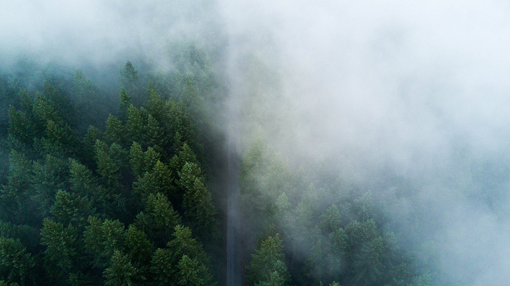
The One Case Where Flying Near Fog Makes Sense
Flying above a fog layer while the drone remains in clear air is a completely different situation from flying in fog, and it produces some of the most spectacular aerial footage available.
Above the fog layer: what makes it safe
Thin, patchy ground fog or valley fog, where the drone stays above the fog bank and remains fully visible at all times, carries none of the risks described above. The drone is in clear air. Obstacle avoidance works normally. VPS works normally. You have unobstructed visual contact. From above, the mist fills valleys and softens the landscape in a way that's genuinely hard to replicate in any other condition.
The key technical distinction: the fog layer is below the drone, not around it. The drone is not flying through fog. The pilot has maintained VLOS throughout. Both conditions are met simultaneously.
How to set up the shot
Morning valley fog works best. Cold overnight air drains into low-lying areas and the fog sits relatively stable until mid-morning when the sun warms it off. The window is usually 30 to 90 minutes after sunrise. Flying from an elevated launch point above the valley, a hillside, a ridge, a raised parking lot, puts you naturally above the fog layer from the start. Launch in clear air, keep the drone within clear air, and film downward into the mist.
The situation to avoid is launching from inside the fog bank with the intention of climbing above it. You can't maintain VLOS during the climb through the fog layer, which means you're in violation during that portion of the flight. Launch from a point already above the fog, or wait for the fog to clear.
Tip: Valley fog typically clears from the edges first as air warms. The thickest, most photogenic fog is usually in the center of the valley or lowest point. Position the drone at the fog boundary for the best shots, looking across the fog surface from above its edge, not straight down into the middle of a featureless white mass.
FAQ
It depends on the fog density and your drone's position relative to it. FAA Part 107 requires a minimum flight visibility of 3 statute miles, fog that reduces visibility below that makes commercial drone operation illegal. Recreational rules require VLOS at all times, which fog typically prevents. Flying above a fog layer while maintaining clear visual contact with the drone in clear air above is legal. Flying into or through fog is not, regardless of what FPV footage shows.
It can, over time. Fog is essentially very fine water droplets, and flying through it exposes the drone to moisture in the same way light drizzle does. Condensation forms inside the gimbal housing and on camera lenses, which can cause gimbal faults and blurry footage. Motors and electronics exposed to repeated fog flights can corrode, particularly if the drone has no water resistance rating. The damage is cumulative rather than immediate.
Fog doesn't block GPS signals directly, satellites are far above the weather. The problem is indirect. Fog disables the drone's visual positioning and obstacle avoidance systems, leaving GPS as the only active positioning method. If GPS signal becomes intermittent in foggy conditions (which can happen due to atmospheric interference near the ground), the drone automatically enters ATTI mode, where it can't hold position and drifts with the wind. RTH also stops functioning in ATTI mode.
ATTI mode (attitude mode) is what your drone falls back to when GPS is lost or insufficient. In ATTI mode, the drone can maintain its orientation and respond to control inputs, but it has no ability to hold position or brake against wind. It drifts. There's no Return to Home. There's no position lock. In clear conditions, an experienced pilot can fly in ATTI mode. In fog, where you can't see the drone, you have no reference to work from, the drone becomes unflyable in practice even if technically responsive.
Yes, cautiously. RTH uses GPS navigation and functions in fog from a positioning standpoint. The problem is obstacle avoidance, in fog, the drone's obstacle detection is degraded, so it may fly into objects it would normally detect and avoid. Before any flight in fog-risk areas, set your RTH altitude high enough to clear all obstacles on the path home. If you use RTH in fog, monitor telemetry actively and be ready to override manually if you know the drone is approaching an obstacle.
Under FAA Part 107, the minimum is 3 statute miles of flight visibility. For recreational pilots, the practical minimum is whatever visibility allows you to maintain unaided visual contact with the drone, the regulation requires VLOS at all times but doesn't specify a distance. In practice, most pilots lose adequate visual contact well before 3 miles. You can check current visibility conditions using METAR reports on the Aviation Weather Center website or the FAA's B4UFLY app.
Yes, if you launch from a position above the fog layer and maintain clear visual contact throughout. Flying from a hillside or elevated point above a valley fog bank, with the drone in clear air, is safe and legal. The footage is excellent. The conditions to avoid: launching from inside the fog, climbing through a fog layer to get above it (which breaks VLOS during the climb), or letting the drone descend into the fog once airborne.
METAR reports from nearby airports are the most reliable visibility data source for drone pilots. Look for the visibility field, it's listed in statute miles in US METARs. Anything below 3SM (3 statute miles) is a no-fly for Part 107 commercial work. "BR" in the weather field indicates mist, "FG" indicates fog. The FAA B4UFLY app incorporates weather data and will flag low-visibility conditions. UAV Forecast also shows visibility as a specific metric in its flight conditions dashboard.
Paul Posea founded Dronesgator in 2015 and has been reviewing consumer drones for over a decade. With 195 YouTube drone reviews drawing 3.55 million views and published work on Digital Photography School, he combines hands-on flight testing with data-driven analysis to help pilots find the right drone.
Marcus Taylor is a UK CAA certified drone pilot and owner of Deployed Consultancy Ltd. With 6 years of commercial experience spanning UN site surveys in West Africa, aerial photography across Europe, Africa, and Japan, and defence consulting, he verifies the technical accuracy of Dronesgator's drone reviews and guides.