• Find My Drone

Drone No-Fly Zones: Complete US Guide for 2026

Updated

By Paul Posea

Drone No-Fly Zones: Complete US Guide for 2026 - drone reviews and comparison

How Drone No-Fly Zones Work: FAA Airspace Classes

FAA airspace classes A through G diagram showing controlled and uncontrolled airspace for drones
FAA airspace is divided into Classes A through G. Most recreational drone flying happens in Class G (uncontrolled) airspace below 400 feet. Controlled airspace (Classes B, C, D, and E surface) requires LAANC or FAA DroneZone authorization.

The FAA divides US airspace into classes that determine who can fly where and with what authorization. Understanding which class you are in is the first step in determining whether a flight is legal.

Class G: where most drone flying happens

Class G airspace is uncontrolled airspace, typically from the surface up to 1,200 feet in rural areas and up to 700 feet near some airports. No FAA authorization is needed to fly in Class G below 400 feet AGL. Most recreational drone flights at parks, fields, and open areas are in Class G airspace. If your B4UFLY app shows green (or your location is far from any airport or restricted zone), you are almost certainly in Class G.

Controlled airspace (Classes B, C, D, E): authorization required

Classes B, C, and D exist around airports of different sizes. Class B surrounds the largest airports (like LAX, JFK, O'Hare). Class C surrounds medium commercial airports. Class D surrounds smaller airports with control towers. All three require FAA authorization before any drone flight, even recreational. Class E surface extensions exist near some airports and also require authorization. The authorization process is covered in the LAANC section below.

Class A: not relevant for drones

Class A airspace begins at 18,000 feet MSL, well above the 400-foot ceiling that applies to drones under Part 107 and recreational rules. No consumer drone operation takes place in Class A.

How to check your airspace class before flying

The FAA's B4UFLY app is the official tool for airspace checks. It shows a color-coded map: green (fly freely), yellow (proceed with caution, check conditions), red (authorization required or prohibited). The Aloft app (formerly Kittyhawk) integrates LAANC authorization directly, so you can check airspace and request authorization in one step. Always run an airspace check for any location you have not flown before, even familiar-seeming open areas.

Permanent Drone No-Fly Zones and Restricted Areas

Beyond controlled airspace, several categories of US airspace and land are permanently closed to drone operations, or require specific authorization that recreational pilots cannot obtain.

Zone TypeRuleKey Details
National Parks (NPS)Total banAll 63 national parks and 400+ NPS sites, since 2014 (36 CFR 1.5)
Washington D.C. area15-mile No Drone ZoneAround Reagan National Airport; 15-30 mile ring requires FAA waivers
Military basesProhibited (Special Use Airspace)MOAs, Restricted Areas, Prohibited Areas on sectional charts
National Wildlife RefugesGenerally prohibitedUSFWS has broad authority to restrict drones as a disturbance
Nuclear power plantsProhibited (permanent)NRC-designated sites; 1,000 ft. buffer enforced under federal critical infrastructure rules
Other national security sitesProhibitedMajor dams, government facilities, critical infrastructure
Stadiums (during events)Prohibited within 3 NMMLB, NFL, NASCAR, NCAA Div I football; 1 hour before to 1 hour after

Part 107 certificate revocation as an enforcement tool

For commercial drone pilots, the FAA's enforcement toolkit extends beyond fines. The agency can suspend or permanently revoke a Part 107 Remote Pilot Certificate for violations including airspace incursions, reckless operation, and flying under the influence. Certificate revocation ends a pilot's ability to fly commercially in the US. The combination of a fine plus revocation is the most common outcome for commercial operators who receive formal enforcement action.

Washington D.C.: the most enforced no-fly zone in the US

The area around Washington D.C. is one of the most complex and strictly enforced drone environments in the country. A 15-mile radius no-drone zone is centered on Reagan National Airport (DCA). Within this zone, no drone flights are permitted without specific FAA authorization, which is extremely difficult to obtain for recreational or commercial pilots outside of approved government operations. A second ring from 15 to 30 miles requires compliance with strict conditions. Violations in the D.C. area are aggressively prosecuted and the Secret Service coordinates directly with FAA on enforcement.

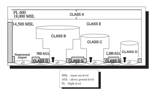
Military and Special Use Airspace

Military Operations Areas (MOAs), Restricted Areas, and Prohibited Areas appear on FAA sectional charts. Prohibited Areas (coded P-XXX) are permanently closed to all civil aviation including drones. Restricted Areas (coded R-XXX) require FAA or military coordination. MOAs are generally available to civilian aircraft when not active but should be checked for activity before any drone flight in or near them. All Special Use Airspace appears in the B4UFLY app and on FAA sectional charts.

Stadium restrictions

FAA rules prohibit drone operations within 3 nautical miles of any stadium hosting an MLB, NFL, NCAA Division I football game, or NASCAR Sprint Cup, Indy Car, or Champ Series race. The restriction begins 1 hour before the scheduled start and extends 1 hour after the event ends. This applies even if the stadium is at a location that would otherwise be Class G airspace. The restriction is automatic and does not require a separate NOTAM to be published for each game.

Prisons and correctional facilities

The FAA prohibits drone flights over federal prisons and many state correctional facilities. The enforcement concern is contraband delivery: drones have been used to drop drugs, phones, and weapons over prison walls in documented cases across the country. Federal correctional institutions are permanently restricted. Many state prisons operate under similar restrictions through state aviation orders or facility-specific TFRs. If B4UFLY shows a restricted marker near a facility, treat it as prohibited regardless of the marker type. Flying over a federal prison without authorization can result in both FAA civil penalties and separate federal criminal charges related to the delivery attempt.

State and local no-fly zones

Federal FAA rules set the floor, not the ceiling. California, Florida, New York, Texas, and most other states have additional drone restrictions that go beyond FAA rules. California prohibits drone flights over active wildfires and emergency scenes under Vehicle Code Section 402. Florida's Freedom from Unwarranted Surveillance Act restricts drone-based surveillance over private property. New York City has specific operational restrictions within the five boroughs beyond standard controlled airspace requirements. Local ordinances at the city and county level add another layer: many municipalities restrict drone flights over city parks, government buildings, and populated areas. The B4UFLY app does not show most state and local restrictions. Checking the specific drone laws for your state before flying somewhere new is a necessary step that airspace apps alone cannot replace.

Temporary Flight Restrictions: Drone No-Fly Zones That Change

Diagram showing controlled and uncontrolled airspace levels for drone pilots
Airspace authorization requirements change based on both permanent class designations and temporary restrictions. TFRs can appear within hours and cover areas that are normally open to drones. Always check NOTAMs on the day you plan to fly.

Temporary Flight Restrictions (TFRs) are issued by the FAA for specific events, emergencies, and security requirements. Unlike permanent restrictions, TFRs appear and disappear. Missing one is a common source of violations.

Presidential and VIP TFRs

When the President, Vice President, or other security-protected individuals travel, the Secret Service coordinates a TFR covering the travel area. Presidential TFRs are typically a 10-mile outer ring and a 3-mile inner ring. All civilian flights, including drones, are prohibited in the inner ring regardless of authorization. Presidential TFRs appear in NOTAM data and in the B4UFLY app, usually with a few hours notice for unannounced movements and sometimes days in advance for planned events.

Wildfire TFRs

The FAA issues TFRs over active wildfires within hours of a new fire starting. The TFR protects air tanker and helicopter operations. Drone interference with firefighting aircraft is a federal crime beyond the TFR violation itself: if a drone forces aerial firefighting resources to pause operations and the fire spreads, federal prosecutors have pursued serious charges. The highest FAA fine in 2025 ($36,770) involved flying near emergency aircraft during an active wildfire. Check for active wildfire TFRs before flying in the western US during fire season.

Space launches

SpaceX, Rocket Lab, and other launch operators coordinate TFRs with the FAA around launch times. Launch-related TFRs typically cover large radius around the launch site. These are published in advance in NOTAM data.

Major events and disasters

Large public events (major concerts, airshows, inaugural ceremonies) and disaster response operations (floods, hurricanes, search and rescue) frequently have associated TFRs. These are not predictable in advance the way stadium restrictions are. Check FAA NOTAMs via the FAA TFR website or through a pilot app on the day you plan to fly.

Getting Authorization for Drone No-Fly Zones

Some restricted zones have an authorization process. Understanding which ones do and how they work matters if you plan to fly in urban areas or near airports.

LAANC: fast authorization for controlled airspace

The Low Altitude Authorization and Notification Capability (LAANC) is the FAA's automated airspace authorization system. It covers roughly 900 airports in the US and provides near-instantaneous authorization for flights in controlled airspace at or below the maximum altitude approved for each grid cell. You request LAANC authorization through an approved app (Aloft, DJI Fly, DroneLink) by selecting your flight area and altitude. Most requests are approved in under a minute. LAANC approval is tied to your FAA registration and the specific location and altitude requested. It expires after a set period and you cannot fly outside the approved parameters.

FAA DroneZone for areas without LAANC

For controlled airspace not covered by LAANC, or for commercial operators with specialized needs, the FAA DroneZone portal handles airspace authorization requests manually. These take longer (days to weeks) and require detailed flight information including equipment, purpose, and safety mitigations. Most recreational pilots will not need FAA DroneZone if they use LAANC-covered areas.

Waivers for restricted operations

Part 107 operators can apply for waivers that allow certain operations normally prohibited under Part 107: flying over people, night flying before the 2021 rule change (now permitted without waiver with proper lighting), flying beyond visual line of sight, and flying from a moving vehicle. Waivers are case-by-case, require detailed safety analysis, and are not available to recreational pilots.

DJI geofencing and what it means for no-fly zones

DJI drones enforce geofencing software that may prevent or warn against flight in certain areas. In 2025, DJI removed its Enhanced Warning Zones, which had been a major source of confusion when DJI's internal geofencing did not match FAA rules exactly. The current DJI GEO system focuses on Restricted Zones (full blocks in military and prohibited airspace), Authorization Zones (prompts for LAANC or self-unlock near airports), and Warning Zones (advisory notices). DJI geofencing is an additional safety layer, not a substitute for checking actual FAA airspace data: the two do not always match perfectly, and pilots are responsible for FAA compliance regardless of what the DJI app permits or blocks.

Tools for Checking Drone No-Fly Zones Before Every Flight

Multiple tools are available for airspace checks. Using at least two of them before every flight at a new location is good practice.

FAA B4UFLY app

The official FAA app for recreational pilots. Shows airspace class, controlled airspace boundaries, national parks, military zones, and TFRs on a map. The color coding (green/yellow/red) gives an immediate status at any location. Free, available on iOS and Android. Limitation: B4UFLY does not provide LAANC authorization directly; it only shows the airspace status.

Aloft app (formerly Kittyhawk)

The most popular full-featured app for drone pilots. Combines airspace maps, LAANC authorization, weather data, and flight logging in one interface. You can check airspace, request authorization, and log your flight all in the same app. Approved by the FAA for LAANC requests. Free for recreational use, with paid tiers for commercial operators needing advanced features.

FAA TFR website

The FAA TFR website lists all active and upcoming Temporary Flight Restrictions with details on location, altitude, and time. It is the authoritative source for TFR data. B4UFLY and Aloft pull from the same data, but checking the TFR website directly before flying in an area near a potential event adds an extra layer of confidence.

AirMap

AirMap is a widely used airspace management platform that supports LAANC authorization and real-time airspace awareness across the US and internationally. Commercial operators managing multiple pilots or automated operations often use AirMap for its API integrations and fleet management capabilities. Recreational pilots can use the AirMap app for airspace checks and LAANC requests as an alternative to Aloft.

FAA SkyVector (sectional charts)

For pilots who want to understand airspace from the perspective of the full aviation system, SkyVector provides FAA sectional charts that show all airspace classes, Special Use Airspace boundaries, VORs, and other navigation features. It is more complex than B4UFLY but gives a complete picture of the airspace environment, which is particularly useful in areas with overlapping restrictions.

Tip: Always check airspace on the day you plan to fly, not the day before. TFRs, especially for VIP movements and wildfires, can appear with little notice and cover areas that were open when you checked the previous day. A 2-minute B4UFLY check on the day of the flight is faster than explaining a violation to the FAA.

FAQ

Drone no-fly zones include controlled airspace near airports (requires LAANC authorization), national parks (total ban since 2014), Washington D.C.'s 15-mile restricted zone, military bases and prohibited airspace, national wildlife refuges, stadium areas during events (3 nautical miles), active wildfire areas, and any location with an active Temporary Flight Restriction. The FAA B4UFLY app maps all of these at your location.

Use the FAA's B4UFLY app before every flight. It shows airspace class, controlled airspace near airports, national parks, military zones, and active TFRs on a color-coded map. Green means fly freely. Yellow means check conditions. Red means authorization required or prohibited. The Aloft app provides the same information and also handles LAANC authorization requests in one step.

Penalties range from warnings to federal criminal charges depending on the zone and circumstances. Civil fines under FAA rules can reach $75,000 per violation under the FAA Reauthorization Act of 2024. Flying in a national park is a federal misdemeanor with up to $5,000 fine and 6 months jail. Interfering with firefighting aircraft during a wildfire can result in felony charges. The FAA's 2026 enforcement posture prioritizes fines over compliance education.

For controlled airspace near airports, yes: LAANC provides near-instant authorization through apps like Aloft or DJI Fly. For non-LAANC areas, the FAA DroneZone portal handles manual authorization requests. For national parks, military prohibited airspace, and Washington D.C.'s inner restricted zone, no public authorization is available. Part 107 operators can apply for operational waivers for certain restricted operations.

Yes. The FAA prohibits drone operations within 3 nautical miles of any stadium hosting an MLB, NFL, NCAA Division I football, or NASCAR Sprint Cup/Indy Car/Champ Series event. The restriction begins 1 hour before the game and ends 1 hour after. This applies automatically without requiring a specific NOTAM and even covers stadiums located in otherwise unrestricted Class G airspace.

A Temporary Flight Restriction (TFR) is an FAA notice that closes a specific area of airspace for a set period. TFRs are issued for presidential travel, active wildfires, space launches, major events, and disaster response. They can appear with hours of notice and cover areas normally open to drones. Always check the FAA's B4UFLY app or TFR website (tfr.faa.gov) on the day you plan to fly, not just in advance.

There is no fixed distance rule. The question is which class of airspace surrounds the airport. Class B, C, and D airports all require LAANC or FAA DroneZone authorization for drone flights, regardless of distance. Some Class E surface extensions near smaller airports also require authorization. The FAA B4UFLY app shows exactly where authorization is required around any specific airport.

FAA rules do not prohibit flying over private property at altitude; the FAA controls navigable airspace. However, state drone privacy laws in California, Florida, Texas, Virginia, and others restrict flying over private property with a camera under certain conditions. Very low-altitude hovering that interferes with the property owner's use of their land can also create legal exposure under trespass or nuisance theories. Check state law for your specific state.

Paul Posea

Paul Posea

Author · Dronesgator

Paul Posea is the founder of Dronesgator and has been reviewing and comparing drones since 2015. With a Part 107 certification, 195 YouTube drone reviews, and published work on Digital Photography School, he combines hands-on flight testing with data-driven analysis to help pilots find the right drone.